
Understanding FEMA's Draft Flood Maps in Houston: A Guide for Real Estate and Photography Enthusiasts
- Adriana Perez

- Apr 22
- 4 min read
Updated: May 6

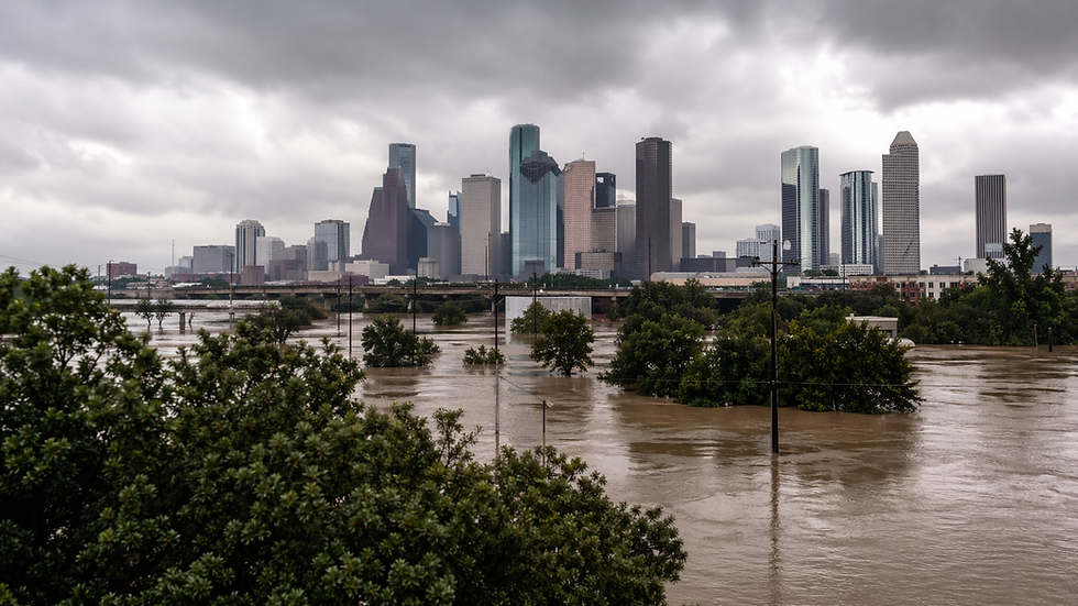
In Houston, water has a long memory. Whether through a creeping tropical system or a sudden, punishing inland downpour, water frequently reminds Harris County that flood risk involves much more than the coast. It tells a continuous story of rainfall, drainage, and a rapidly expanding built environment fighting to keep pace.
The Importance of Updated Flood Maps
This deep-rooted history underscores the importance of Harris County’s newly released FEMA-backed draft flood maps. A colored line on a map does not manufacture danger; rather, it attempts to capture the reality of the risk that already exists.
These MAAPnext maps are currently drafts, shared strictly for awareness and technical review. They hold no regulatory weight yet and cannot dictate insurance rates or development decisions today. Simply appearing differently on the draft viewer changes nothing immediately about your mortgage or insurance bill. Instead, this phase gives the region a vital opportunity to look honestly at its relationship with water.
Since the last major maps were issued in 2007, our county, our data, and our storms have evolved. The Harris County Flood Control District notes that the new modeling accounts for a 30% jump in rainfall rates, updated topography, and recent mitigation projects completed through 2020. Upgraded engineering assumptions drive these changes, reflecting the hard lessons Houston has learned over the past two decades.
A History of Flooding in Houston
Many long-time residents trace their modern understanding of flood risk back to Tropical Storm Allison in June 2001. Allison proved that a storm requires no hurricane-force winds to devastate a city. By stalling and dumping nearly 37 inches of rain near the Port of Houston, it claimed dozens of lives and fundamentally reshaped our view of vulnerability.
Hurricane Ike followed in 2008, bringing a completely different threat. As a wind-and-surge storm, Ike pushed Gulf water inland and crippled power and transportation networks. It demonstrated that regional resilience relies heavily on the infrastructure surrounding our homes.
The illusion that flood risk belonged only in a handful of obvious places completely shattered during the Memorial Day and Tax Day floods of 2015 and 2016. Hurricane Harvey in August 2017 delivered the final blow, bringing catastrophic drainage failures and record river levels. Harvey flooded thousands of homes and proved that mapped risk and lived experience often diverge.
Bridging the Gap with Draft Maps
Today’s draft maps aim to bridge that gap. They represent current vulnerabilities based on updated rainfall data, terrain, and infrastructure. Early independent estimates suggest the 1% annual-chance floodplain could grow substantially across Harris County. The term "100-year floodplain" often misleads people into expecting one flood per century. In reality, it signifies a 1% chance of flooding in any given year—a risk that compounds significantly over a 30-year mortgage. False comfort in a rapidly developing region with extreme weather can be incredibly costly.
FEMA’s modern Risk Rating 2.0 prices flood insurance using specific property characteristics rather than relying solely on old zone-based methods. While map changes heavily influence whether a lender requires coverage, your exact premium depends on a wider set of property-level risk factors.
Practical Considerations for Homeowners
If the final maps place a home in a higher-risk zone, practical questions will surface quickly. Homeowners must consider elevation certificates, past flooding, and recent drainage improvements. Smart sellers will gather this information long before a transaction forces the issue.
Buyers must also dig deeper than the flood-zone label. Review seller disclosures, secure insurance quotes before closing, and examine the property's elevation relative to the street. Investors face similar scrutiny, as flood risk serves as a critical underwriting variable. Lazy analysis fails in this market, so investors must carefully evaluate insurability, elevation context, and how future buyers might discount the asset.
The Ripple Effect on Infrastructure and Housing
Expanding floodplain boundaries also ripple through infrastructure planning, roadway design, and housing supply. As land becomes tougher or more expensive to develop, pressure shifts across an already affordability-strained region. These draft maps offer a valuable preview of where the market is heading and where underwriting may tighten.
Property owners should act proactively. Check your address on the MAAPnext viewer and the FEMA Map Service Center to compare current effective maps with the new drafts. Gather existing surveys, elevation certificates, and prior flood documentation. Secure a real flood insurance quote now if you sit near a higher-risk area, and avoid waiting for an underwriter or a real estate listing to raise the issue.
Conclusion: The Value of Awareness
Houston remains a resilient city, shaped by both named hurricanes and ordinary rain events turned extraordinary disasters. The new draft maps simply reflect this history. By forcing honest conversations about land use, insurance, and preparedness, they provide immense value. In Houston, the most expensive flood risk is the one you assume does not apply to you.
Important Note & Disclaimers
This article is for general informational purposes only and is not legal, engineering, surveying, insurance, or floodplain determination advice. The Harris County MAAPnext maps discussed here are draft awareness maps as of February 2026 and are not yet final regulatory flood maps. Flood zone designations are subject to change following the public review and appeal process.
Boundary lines on digital viewers may not reflect exact on-the-ground elevation differences. An elevation certificate or professional survey may be necessary to determine true flood risk. Property owners, buyers, sellers, and investors should verify flood-zone status, insurance requirements, pricing, and any appeal options directly with FEMA, the applicable local floodplain administrator, licensed insurance professionals, and qualified engineers or surveyors before making financial or real estate decisions.


Comments